Tuesday, April 22, 2008

Spring?

IMG_1308Spring delays!

Normally, the ice melts on the big lake near Ely about April 28.

I wait and worry. Spring delays! It's late this year - 1 to 2 weeks.

My brother and I plan a spring hike along the edge of the BWCA near Ely. We must canoe to the beginning point of this hike. We have an entry permit for Crab Lake on May 5thWolf Lake Road

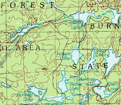
He and I will explore some old logging road in the old portal zone between Lake Vermillion and Burntside. Logging occurred in areas of the wilderness in the years before 1978, the so-called portal zones. Some of the many logging roads out of Forest Center near Lake Isabella in the east became part of the Pow Wow Hiking Trail.

The logging roads accessed from the Wolf Lake Road were abandoned. The easements reverted back to private land. You can see a portion of the logging road on the map.

We wish to see what remains of these roads after 30 years.

Thursday, April 10, 2008

The Blizzard of 2008 ??

Duluth and Cloquet sit in the middle of a meteorological bull's eye. The Weather Service warns, image

"CARLTON/SOUTHERN ST. LOUIS-DOUGLAS-423 AM CDT THU APR 10 2008
...BLIZZARD WARNING REMAINS IN EFFECT FROM 7 PM THIS EVENING TO 7 AM CDT SATURDAY...
NORTHEAST WINDS GUSTING TO 50 MPH...COMBINED WITH HEAVY SNOW...WILL RESULT IN A PROLONGED PERIOD OF HAZARDOUS WHITEOUT CONDITIONS FOR LOCATIONS NEAR LAKE SUPERIOR...INCLUDING THE TWIN PORTS...WEST TO FLOODWOOD...SOUTH TO AROUND BARNUM...AND EAST TO BENNETT WISCONSIN.
TOTAL SNOW ACCUMULATIONS OF 11 TO 16 INCHES. LOCALLY HIGHER AMOUNTS ARE POSSIBLE. 
A BLIZZARD WARNING MEANS SEVERE WINTER WEATHER CONDITIONS ARE EXPECTED OR OCCURRING. FALLING AND BLOWING SNOW WITH STRONG WINDS AND POOR VISIBILITIES ARE LIKELY. THIS WILL LEAD TO WHITEOUT CONDITIONS...MAKING TRAVEL EXTREMELY DANGEROUS. DO NOT TRAVEL."


This morning the Mayor of Duluth announced, 

From Mayor Don Ness:
To all employees:
The likelihood of a major snowstorm hitting the city during work hours on Friday prompts me to let you know the following:image
Our current plan is for City Hall to be open on Friday. Police, Fire and Public Works employees should plan on coming to work. Department directors should ensure that there is access to remote facilities.
Employees in other departments may elect to use either personal leave or vacation time if they are not able to reach work on Friday morning. All employees should listen to local media on Friday morning to learn if their facilities are closed to the public.
All employees are urged to monitor local media for any bulletins concerning city operations. We will update local media regularly throughout the storm situation, as required. Thank you for your consideration.
Don Ness
Mayor

Our last notable blizzard struck on March 1, 2007,

"Snowfall of over 20 inches and winds over 50 mph hit the northland last weekend (February 28-March 2). It was felt the hardest in Duluth where it will be remembered as the blizzard of 2007." 

Blizzard of 2007 Storm Summary by NOAA.

Many of us remember the famous Halloween Storm of 1991:

Halloween Snow Storm, October 31 – November 2, 1991
A major early-season snowstorm struck northeastern Minnesota and northwestern Wisconsin from late on Halloween, 1991, into the early morning of November 2. The storm dumped 15 to 36 inches of snow, with the highest totals falling along the Wisconsin-Minnesota border. Snowfall rates occasionally ranged from 1 to 2 inches per hour. Strong northwest winds created 6 to 10 foot drifts. The storm closed schools, businesses, and transportation systems- some for several days.

I plan to remain at home tomorrow and experience the Thundersnow & Thundersleet which the Updraft Blog forecasts

The strong dynamics and forcing with this storm will mean thunderstorms may develop as well. Thundersleet or thundersnow is a possibility tonight as the strongest part of the storm draws near.

Stay safe.